Atomic Open House is situated within a landscape shaped by overlapping histories of nuclear testing, military land use, mining, tourism, Indigenous sovereignty, and desert ecology. Located in Beatty, Nevada, the artwork sits near the Nevada National Security Site and Yucca Mountain, while also occupying a town whose history predates and extends far beyond the nuclear era.
The work’s location is therefore not incidental. Atomic Open House invites visitors to consider how a place can hold multiple, sometimes contradictory histories at once: a landscape of extraction and preservation, secrecy and spectacle, danger and recreation, absence and habitation.
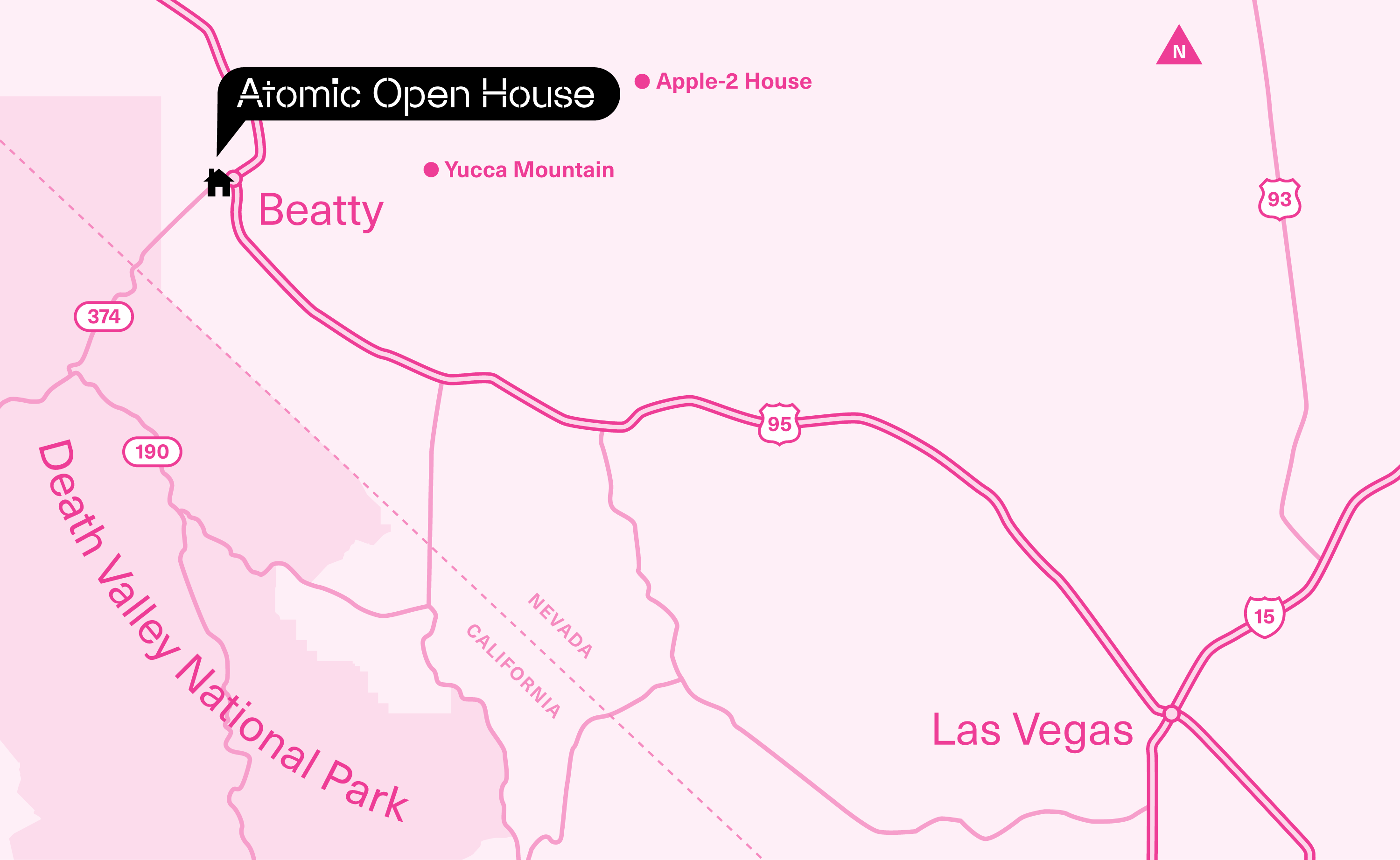
As a site-specific artwork, Atomic Open House is intended to be in dialogue with the unique qualities and histories of its surrounding environment. Located in the rural town of Beatty, Nevada (population 908 as of the 2020 U.S. Census), the artwork sits one block from the intersection of U.S. Route 95 and Main Street. This location is approximately 18 miles west of Yucca Mountain and the western edge of the Nevada National Security Site (NNSS). Placing Atomic Open House in Beatty invites reflection on the town’s relationship to atomic testing and military land use, tourism, and the surrounding desert ecology.
Beatty’s history is layered. While you will find information about some of these layers below, we encourage you to connect with local institutions like the Beatty Museum and Historical Society and the Beatty Chamber of Commerce for deeper insights. Have additional knowledge you’d like to share? Email hello@blackcube.art.
Beatty
+
Nuclear Testing
- 1Sauvageau, Carly. “Complicated Legacy of Nuclear Testing in Nevada Lives on in Bodies, Politics.” The Nevada Independent, September 17, 2023. https://
thenevada .independent .com /article /complicated -legacy -of -nuclear -testing -in -nevada -lives -on -in -bodies -politics - 2“Nevada Test Site.” Atomic Heritage Foundation, National Museum of Nuclear Science & History. Accessed October 2, 2026. https://
ahf ..nuclear museum .org /ahf /location /nevada -test -site/
Beatty is one of the closest inhabited towns to the Nevada National Security Site (NNSS), formerly known as the Nevada Test Site (NTS). Between 1951 and 1992, the 1,350-square-mile Site was used by the United States government to test nuclear bombs.1 During this era, the Site hosted 928 nuclear tests, 100 of which were atmospheric detonations.2 The mushroom clouds from the above-ground detonations could be seen—and felt—in nearby communities.
- 3McCracken, Bob. “Growth of Test Site brings pressure to Beatty brothels.” Pahrump Valley Times, October 31, 2014. https://
pvtimes ..com /news /growth -of -test -site -brings -pressure -to -beatty -brothels/ - 4McCracken, Robert D. “An Interview With Jack & Maud-Kathrin Crowell.” Nye County Town History Project, Beatty Museum. 1990, 134. https://www
.beatty .museum .org /oral /crowell /crowell2 .pdf - 5Palevsky, Mary. “Interview with Oliver Wilhelm Kaufmann, November 29, 2005.” Nevada Test Site Oral History Project, University of Nevada, Las Vegas Special Collections and Archives. November 29, 2005, 10. https://
special ..library .unlv .edu /ark%3A /62930 /d15m62j97 - 6Becker, Suzanne. “Interview with Stuart C. Black.” Nevada Test Site Oral History Project, University of Nevada, Las Vegas Special Collections and Archives. January 18, 2005, 6. https://
special ..library .unlv .edu /ark%3A /62930 /d1g15tp1t
In Beatty, the presence of the Nevada Test Site shaped employment, commerce, and everyday life. New employees shaped the town, leading to the opening of, according to the Pahrump Valley Times, “a half a dozen bars and gambling casinos, five gas stations, and a handful of cafes and motels,” as well as “up to seven brothels.”3 One local oral history reflects on how “a lot of people we know and live with as friends wouldn’t be here if it were not for the Test Site.”4 Other oral histories from employees of the United States Public Health Service, tasked with monitoring radioactive fallout in the areas around the NTS, recall experiences of setting up monitoring equipment in a Beatty brothel5 and testing milk samples from dairy farm cows.6
Also close to Beatty is Yucca Mountain, site of a proposed deep geological repository for spent nuclear fuel (a byproduct from commercial nuclear power plants) and high-level radioactive waste (a byproduct of producing nuclear weapons). Originally proposed in 1987, the Yucca Mountain repository has remained controversial well into the 21st century (visit the University of Nevada, Reno’s “Yucca Mountain Project Timeline” for more).
Human History
- 7“Treaty with the Western Shoshoni, 1863.” Tribal Treaties Database, Oklahoma State University. https://
treaties ..okstate .edu /treaties /treaty -with -the -western -shoshoni -1863 -0851 - 8Solis, Jennifer. “Western Shoshone step up resistance to Yucca project.” Nevada Current, May 14, 2019. https://
nevada .current .com /2019 /05 /14 /western -shoshone -step -up -resistance -to -yucca -project/
Beatty and its surrounding areas (including the Nevada National Security Site) are part of the ancestral homelands of Indigenous peoples, including Western Shoshone and Paiute communities. In 1863, the Western Shoshone signed a treaty of peace and friendship with the United States.7 While the Western Shoshone retained ownership of the lands they inhabited, the treaty enabled the federal government to establish military posts, prospect for gold and silver, and build settlements and infrastructure on them. No land was ceded, but over time, much of it was taken over by federal agencies, including the Atomic Energy Commission.8
- 9Beatty Museum and Historical Society. https://
www ..beatty nevada .org /covers /Beatty Museum .pdf - 10“History of Beatty.” Beatty Nevada. https://
www ..beatty nevada .org /history .html
In 1904, gold was found in the area. Several small mining towns, including Beatty, Rhyolite, and Bullfrog sprang up, forming the Bullfrog Mining District. According to the Beatty Museum, Beatty “came into its own by the 1930’s [sic] and is now the only surviving town of the original Bullfrog Mining District.”9 The town’s website echoes this last-man-standing sentiment, suggesting that Beatty’s unique access to water and its position as a rail hub enabled its perseverance.10
Today, Beatty continues to serve residents, workers, and travelers exploring the surrounding desert, including visitors headed to Death Valley, bird watchers, and mountain bikers.
Desert Ecology
Located in the Mojave Desert and part of Oasis Valley, Beatty sits at approximately 3,320 feet above sea level. The area is characterized by an arid desert climate, with large variations in temperature between day and night and significant seasonal temperature extremes.
- 11“Amargosa River.” American Rivers. https://
www ..american rivers .org /river /amargosa -river/
Notably, Beatty is part of the Amargosa River watershed. The Amargosa River begins near Pahute Mesa within the NNSS, flows through Beatty, and continues through Nevada and California toward Death Valley. Much of the river flows underground through the desert, sustaining springs, wetlands, wildlife, and human communities along its course. Its largely hidden presence complicates the familiar image of the desert as barren or vacant: what is not immediately visible may be integral to the life of a place.11
- 12“Explore Important Bird Areas.” Audubon Society. https://vgis
.audubon ..org /portal /apps /dashboards /1742b c47f98 0490da 9c23e23dc 4d5e86# site =940
Supported by the river, the area around Beatty is home to many unique species of fauna, including wild burros, pupfish, the Amargosa Toad, and the Desert Tortoise. The region is designated by the Audubon Society as an Important Bird Area (IBA), with the Amargosa River providing one of the only sources of guaranteed water to birds migrating between the Mojave Desert and the Great Basin.12
- 1Sauvageau, Carly. “Complicated Legacy of Nuclear Testing in Nevada Lives on in Bodies, Politics.” The Nevada Independent, September 17, 2023. https://
thenevada .independent .com /article /complicated -legacy -of -nuclear -testing -in -nevada -lives -on -in -bodies -politics - 2“Nevada Test Site.” Atomic Heritage Foundation, National Museum of Nuclear Science & History. Accessed October 2, 2026. https://
ahf ..nuclear museum .org /ahf /location /nevada -test -site/ - 3McCracken, Bob. “Growth of Test Site brings pressure to Beatty brothels.” Pahrump Valley Times, October 31, 2014. https://
pvtimes ..com /news /growth -of -test -site -brings -pressure -to -beatty -brothels/ - 4McCracken, Robert D. “An Interview With Jack & Maud-Kathrin Crowell.” Nye County Town History Project, Beatty Museum. 1990, 134. https://www
.beatty .museum .org /oral /crowell /crowell2 .pdf - 5Palevsky, Mary. “Interview with Oliver Wilhelm Kaufmann, November 29, 2005.” Nevada Test Site Oral History Project, University of Nevada, Las Vegas Special Collections and Archives. November 29, 2005, 10. https://
special ..library .unlv .edu /ark%3A /62930 /d15m62j97 - 6Becker, Suzanne. “Interview with Stuart C. Black.” Nevada Test Site Oral History Project, University of Nevada, Las Vegas Special Collections and Archives. January 18, 2005, 6. https://
special ..library .unlv .edu /ark%3A /62930 /d1g15tp1t - 7“Treaty with the Western Shoshoni, 1863.” Tribal Treaties Database, Oklahoma State University. https://
treaties ..okstate .edu /treaties /treaty -with -the -western -shoshoni -1863 -0851 - 8Solis, Jennifer. “Western Shoshone step up resistance to Yucca project.” Nevada Current, May 14, 2019. https://
nevada .current .com /2019 /05 /14 /western -shoshone -step -up -resistance -to -yucca -project/ - 9Beatty Museum and Historical Society. https://
www ..beatty nevada .org /covers /Beatty Museum .pdf - 10“History of Beatty.” Beatty Nevada. https://
www ..beatty nevada .org /history .html - 11“Amargosa River.” American Rivers. https://
www ..american rivers .org /river /amargosa -river/ - 12“Explore Important Bird Areas.” Audubon Society. https://vgis
.audubon ..org /portal /apps /dashboards /1742b c47f98 0490da 9c23e23dc 4d5e86# site =940